The opportunities of our staying in Varia, which is Stratos’ village, as a part of our Easter Holidays, lead us to visit the area that extends in the border of the two neighboring prefectures: Etoloakarnanias - Evrytanias. Stratos had made in the past part of the route, and he totally recommends this route!
At 12pm, we left the village Varia located on the shores of Lake Trichonida, the largest lake in Greece. In the village there are some lovely viewpoints and planes. However, tourism development is not great. Moving on road to “Paravola” and before the end of village Varia we followed the narrow road that passes through the small church of Varia. Possibly, it's quite hard to find this road if you had no knowledge of this area. However, if someone could not find this road he can move to Paravola village and follow the well signposted road (signs for Proussos). The route offers many places with wonderful panoramic views of the lake. The vegetation was low, consisting of olives and oaks.
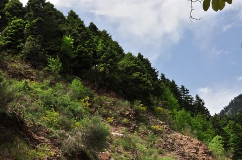
Soon we pass village Neromana (4km away from Varia). The old name was "Soumpoliko", probably derived from the Turkish words: «su» (=water) + «bol»-iko (= abundance), meaning "plenty of water", due to the presence of many running waters! Having covered about 10km. by Varia and shortly after the village Kallithea, we entered into an area with more vegetation and many trees. We drove alongside a rushing small river in area named "Makrialonga." The helical narrow road follows the steep terrain. It was really impressive!
We passed the small village Lampiri and after a few kilometers we were in an area named "Arapokefala" ( in English means Nigger heads), which marks the boundaries of two prefectures (Etoloakarnanias –Evritanias). The name of the area is because of the presence of some big black rocks. These rocks do not now exist they destroyed on construction of the road, so now-only the name remains to remind their presence.
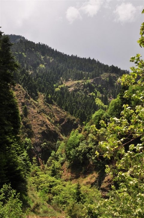
We made a short stop to enjoy the view at an altitude of about 1400m. From this point the road moving into an area full of trees and sycamores. Driving about 6-8km. we arrived at the junction leading to the village Proussos. We turned right following signs to village Tornos and after a while we found the entrance of a small gorge. We left our bikes and pedestrians, we followed the trail.
The scenery was amazing consisting of trees and dense vegetation. Soon we reached the waterfall, is a major attraction of the gorge and not unfairly! Continuing, the trail ended in the "Black Cave". It is a huge opening of the Rock, which during the 2nd World War, was a refuge for local residents. The landscape is unique and impresses even the most discerning visitor! The specific path (over 20-30 minutes), is part of a network of trails of the area with numerous and impressive sights.
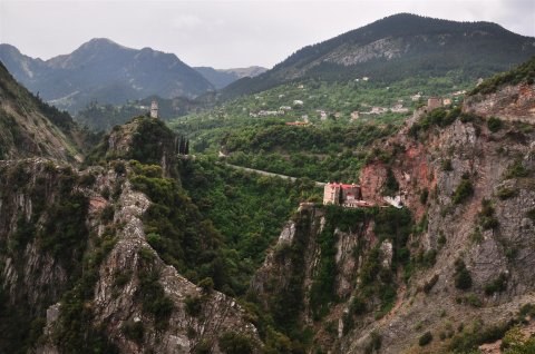
Our next destination was the monastery of Proussos. It is built on a majestic landscape, a steep, rocky area between the mountains Chelydona, Kaliakouda and mountain Timfrystos, which is overgrown with trees. The monastery is committed to “Holly Maria of Proussa”. The Holly Maria’s image according the history has it origin from Bursa in Asia Minor.
The Proussos Monastery is one of the few monasteries preserved in Evrytania. The small church has interesting architecture. To its west, in the root of the rock, there is a crypt formed into a chapel. The sacristy of the monastery contains many valuable manuscripts, icons, sacred vessels, reliquaries and books. Outside the monastery there are two castles left and right, the "towers of Karaiskakis".
After having spent some time in the area around the monastery, we took the road for Karpenisi (35km).The route was beautiful and we made our next stay in the location “Patymata tis Panagias“, means in English “The Holly Marias taps” It is a surprising and for many unexplained geological phenomenon, as in the vertical rock there are embedded seven different colored shapes looked liked as footprints. From this point, according to tradition, the Virgin Mary passed on her way to Proussos.
The central square of the Evrytania capital hosted us for as the time we spend enjoying our afternoon coffee. Karpenisi is a beautiful tourist destination, especially during the winter months. However, for those who love the mountains, can be visited and stunning in every season!
The time was 5pm. when we decided to depart with destination village Krykello, located in the mountain Kaliakouda. We follow the path from which we approach the Karpenisi (direction Agrinio) and after 6km. we met the junction "Klafsio-Mouzilo-Sygkrellos." We turned left and drove on a narrow path with a lot of turns.
The desert road crossing a wooded area of pine trees that made us feel that we were in the Alps ... There were few times when I thought that many of us looking for routes abroad in order to drive on routes that exist in our own country! There were not few times that we stopped to enjoy the view of the area...
Having covered 24km, entered to the Krykello. It is located at an altitude of 1200m. The village has a long history, there is there a monument built to commemorate the victory of the Aetolians and Evritanians against the invading Gauls held in 279 BC! Krykello has been set in a pine forest, it is has beautiful stone traditional houses with a central square where located the stone church of St. Nicholas.
Although it was late and we was sure that we had to drive in night dark, and also known that we couldn’t enjoy much of the rest of the route, Krikello had magnetized us, so we decide to drink a coffee in one of the cafes in the square . Bellow 2-3 large trees, the villagers enjoyed relaxing... so do we! It is a truly beautiful village that you have to visit it...
We left Krykello and follow the road to Domnista-Arachova thought a stunning landscape. In Arachova we met the impressive road went around Evynolimni, directing in the unanimous dam. Having visited the area in a previous trip (two days earlier) we continued apace to Thermo, having as our final destination the village of Varia.
It was deep dark when we had approach the end of our route. A thought was in my mind: “...how many unknown and beautiful places in Greece are waiting for us to visit them... It is in our hands, to discover them!”


 / Proussos gorge")
 / Proussos gorge")
 / Proussos gorge")
 / Proussos gorge")
 / Proussos gorge")
 / Proussos gorge")
 / Proussos gorge")
 / Proussos gorge")
 / Proussos gorge")
 / Proussos gorge")
 / Proussos gorge")
 / Proussos gorge")
 / Proussos gorge")
 / Proussos gorge")
 / Proussos gorge")
 / Proussos gorge")
 / Proussos gorge")
 / Proussos gorge")
 / Proussos gorge")
 / Proussos gorge")


 / Kaliakouda mountain (route to Krikello)")
 / Kaliakouda mountain (route to Krikello)")
 / Kaliakouda mountain (route to Krikello)")
 / Kaliakouda mountain (route to Krikello)")
 / Kaliakouda mountain (route to Krikello)")


